Index

Kentucky Lake -- Tennessee Trio
Standing Rock, Leatherwood, & Hurricane Creeks

This is the index image for the Tennessee Trio map series.

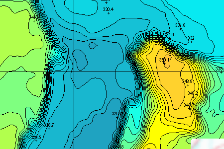
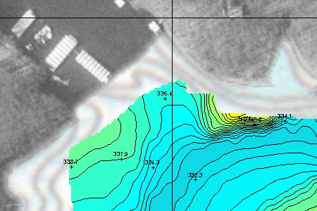
The areas faintly outlined in blue represent the portions of the bays that have been re-mapped. The surrounding black line represent the supplemental nav chart and aerial photography used as a background.

NEW depth data was collected in September & October of 2002.

The high resolution imagery (1 - foot contour intervals) for this data set is based on over 50,000 depth readings.

3 independent sections are shown on the left.

The high resolution images (example below) are actually a hybrid image including the brand new data, plus background imagery. Included in the background is aerial photography and a transparent overlay of the navigation chart to help get oriented with real world features.

Topographic images on CD each contain a latitude/longitude grid and coordinates for easy calibration with GPS mapping software.

This is a sample from the Standing Rock Data. This is near the junction with the Tennessee River.

Latitude/Longitude grid lines are provide on the topo maps for easy calibration with GPS mapping software.

The contour interval on this image is 1.0 foot to reveal as much topographic detail as possible.

Numerous spot elevations are included on all sections for easy reference. If you know the current lake elevation, then water depth can be easily calculated.


This image illustrates the "background" to all the High Resolution topography.

Aerial photography covers the non-water portions of each map section.

Every point and minor bay is well represented even in non-re-mapped areas.

You can see Leatherwood Resort adjacent to the new topography.


Very Cool !!!! Photorealistic Animations


A dramatically improved 3d imaging technique has been used to produce "animated" movies of each re-mapped section.

The summer pool level of 359 ft is represented on non-surveyed areas as the light blue you see here. A simulated water level is then established well below summer pool to help our eye conceive relative heights and placement of features.

This is only 1 frame of a 290 frame animated fly-through for Leatherwood Creek.

Other items included on the CD
(not shown here) include:

A very functional shareware version of OziExplorer GPS Mapping software is provided on disk to get you started with precision fishing. The HydroGrafx images work flawlessly with this version.


Click Here to Purchase

Click here to see Blood River or Jonathan Creek or Little River or Eddy Creek
or Big Sandy (north) or Kentucky East Side Bays (North)

Home Page

If you have any questions about this product, you can email us here pdghahs@kentuckyhydrografx.com

Copyright 2001 Kentucky HydroGrafx, LLC, A Kentucky Limited Liability Company.