Index

Barkley Lake -- Donaldson Creek
*Released September 2003

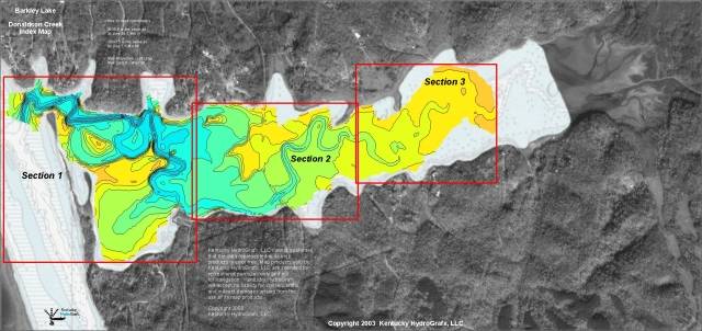
This is the index map for the new Donaldson Creek Imagery.

The area in color is the portion of the bay that has recently been re-mapped.

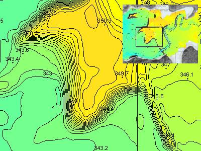
The high resolution topography is based on NEW depth data collected in September of 2003.

The imagery for Donaldson is based on over 30,000 depth readings covering nearly 400 acres.

The area is divided into 3 sections. Topographic images for each section contain a contour interval 0.25 - 1.0 foot.

As you see here, the images are actually a hybrid image including the brand new data, plus background imagery of Chart 1104. Also included in the background is aerial photography to help get oriented with real world features.


Topographic images on CD each contain a latitude and longitude grid and coordinates for easy calibration with GPS mapping software.

This is a high resolution sample from Section 2.

Latitude/Longitude grid lines are provide on the topo maps for easy calibration with GPS mapping software.

The contour interval in this sample is 0.5 foot. Section 1 has a contour interval of 1.0 foot, while Section 3 has an interval of 0.25 foot. Yes, that is one-quarter of a foot!!

Spot elevations are included for easy reference. If you know the current lake elevation, then water depth can be easily calculated.


The now very popular 3D Animation is included with this set. An animation of the entire bay has been produced for this map series.

Similar to the most recently released map imagery, the Donaldson Bay series includes a very impressive flythrough animation of the newly mapped area.

One full animation covers the entire bay for this set.

While this is a still image, the product CD includes the animation.


Other information included on the CD (not shown here) for Donaldson Creek include:

Clip of navigation charts 1104 that encompass the area represented in this set.

A DEMO version of OziExplorer GPS Mapping software is provided on disk to get you started with precision fishing. The HydroGrafx images work flawlessly with this version.


Click Here to Purchase

Click here to view the entire list of Kentucky HydroGrafx products

Home Page

If you have any questions about this product, you can email us here pdghahs@kentuckyhydrografx.com

Copyright 2003 Kentucky HydroGrafx, LLC, A Kentucky Limited Liability Company.