Index

Purchase
Barkley Lake Northwest
*released September 2005

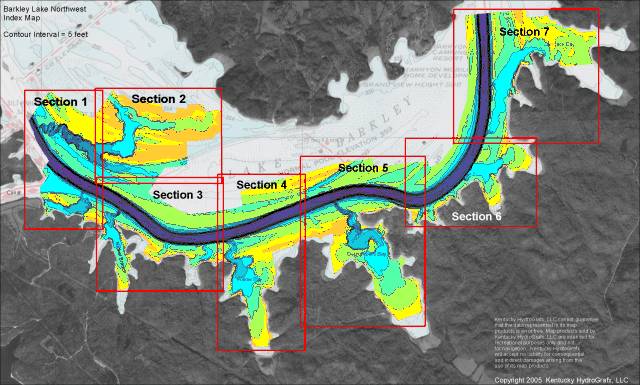
This is the index map for the new Barkley Lake Northwest imagery.

The area in color is the portion of Barkley Lake that has recently been re-mapped. This area is immediately upstream of Barkley Dam and includes data between Cumberland river miles 32 - 38.

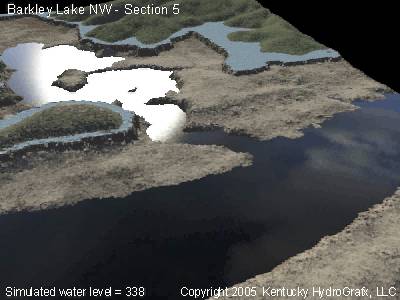
NEW depth data was collected from August 2004 through August 2005

The new maps include portions of Nickel branch, Willow Bay, Demumbers Bay, and Carmack Bay.. A very impressive secondary channel makes up a large percentage of map sections 1 & 2.

The high resolution imagery for Barkley Lake Northwest is based on over 400,000 depth readings covering more than 3000 acres.

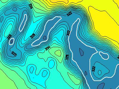
The area is divided into 7sections. Topographic images for each section contain a contour interval of 2 feet.

The images are actually a hybrid image including the brand new data, plus background imagery of Chart 1101 and surrounding aerial photography.

Topographic images on CD each contain a latitude and longitude grid and coordinates for easy calibration with GPS mapping software.

This is a high resolution sample from Section 2 just northeast of the Canal.

The contour interval in this sample is 2.0 feet. Due to the extreme ranges of depth in all sections, the 2 foot interval is used throughout this dataset.

Contour line elevations are distributed throughout all High Resolution sections for quick reference to real world depth.


The next step in 3d viewing has been included with all high resolution Barkley Lake Northwest Images

Similar to the most recently released map imagery, the Barkley Lake Northwest set includes the extremely popular "Fly-through" 3d models.

Each map section has it's own animated movie to help visualize the terrain below the water's surface.

This image is from section 5 and depicts the intersection of Demumbers Bay creek channel with the Cumberland River. This image is a view to the southwest from the northeast corner of section 5.

While this is a still image, the product CD includes the full animation.


Other images included on the CD (not shown here) for Kentucky Lake Northwest include:

Clip of navigation charts 1101 that encompass the area represented in this set.

A DEMO version of OziExplorer GPS Mapping software is provided on disk to get you started with precision fishing. The HydroGrafx images work flawlessly with this version.


Click Here to Purchase

Click here to view the entire list of Kentucky HydroGrafx products

Home Page

If you have any questions about this product, you can email us here pdghahs@kentuckyhydrografx.com

Copyright 2005 Kentucky HydroGrafx, LLC, A Kentucky Limited Liability Company.